As part of the West Ham Flood Alleviation Scheme, Thames Water commissioned the construction of a tunnel that passed approximately 15-20m below the south end of the Stratford Market London Underground depot train stabling roads, Jubilee Line running lines into Stratford Station, the spur line into the depot and the Dockland Light Railway Abbey Road construction site. As a result of the construction of this flood alleviation tunnel some vertical surface ground movement was expected, which potentially could have had an adverse effect on the infrastructure above and the safe operation of the railway systems. Consequently a programme of precise survey monitoring was required to check for any movement.
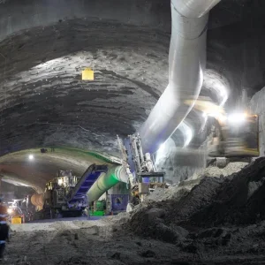
The tunnel was driven by contractor Costain using a Lovat M132 Series 25000 Earth-Pressure-Balance (EPB) TBM with an outer diameter of 3.35m and an internal diameter of 2.87m. A Tacs guidance system was fitted to the TBM using a Leica 1201 total station with telescope-mounted laser for positional information. The total length of the tunnel drive was 3.3km, the TBM being launched from the 12.5m-diameter T1 shaft at Abbey Mills pumping station and arriving at the reception shaft T5 after passing through shafts T2, T3, and T4.
A surface survey network was observed using Leica 1201 instruments and calculated using the Star*Net adjustment package to produce a ‘least squares networks’ solution. A level traverse was run on the surface along the tunnel route using a Leica DNA03 with invar staff, which was used to strengthen the vertical aspect of the control network. After the TBM passed through each intermediate shaft a wire drop was carried out to verify the tunnel survey control by means of a Weisbach triangle method – a method of joining over ground and under ground control networks.
Monitoring
In order to ensure that any potential ground movement would be identified, Costain Engineering, the contractor undertaking the tunnelling work, consulted and worked closely with London Underground and Tube Lines Infrastructure Protection Department (now both part of Transport for London (TFL). Tube Lines is responsible for Jubilee Line infrastructure. Costain implemented a ‘real time’ and manual precise deformation system covering all of the areas likely to be influenced by the tunnel construction. The Deformation Monitoring Package was awarded to Survey Associates (SAL), which was responsible for the design, installation and implementation of both the automated and precise 3-D monitoring undertaken for the duration of the contract.
Implementation of the deformation monitoring scheme was to determine the extent of any ground movement and to ensure that the London Underground and Docklands Light Railway assets were protected. Tube Lines had specified that deformation monitoring of specific areas of the depot was to be carried out during the pre-construction, construction and post-construction phases of tunnel construction.
The basis of the automated systems was to set up arrays of 3-D points along the tunnel alignment in order to produce classic settlement curves. Resulting measurements were then processed and presented through Leica’s GeoMoS monitoring software.
This software is composed of two main applications called ‘Monitor’ and ‘Analyzer’. Monitor is the online application responsible for the sensor control, collection of data, computation and event management. Analyzer is the offline application responsible for the analysis, visualization and post-processing of data.
Leica GeoMoS stores all measurements and results in an open SQL database. The data can be accessed both locally and remotely using Leica GeoMoS Analyzer, Leica GeoMoS Adjustment or third party software. The GeoMos system proved to be very versatile and configured to ensure that deliverables were precisely as required.
Survey Associates commented, “The GeoMoS software’s ease of use and open source database structure allowed us to create bespoke deliverables”.
To cover the ‘live’ area in construction a ‘fluid’ system of five permanent automated total stations and one ‘roving’ total station was used. This enabled ‘real-time’ analysis of the effect of tunnel construction on the surface and the relevant infrastructure.
Lyndon Preece, Costain Project Manage, confirmed the importance of such monitoring. “Monitoring enabled the ground levels to be analysed in real time, which helped minimise surface settlement”, he said.
High-precision automated surveying equipment was used in the survey observations: Leica TCA1201, TCA2003 and TCA1800 total stations and GPH1P precision reflectors with Leica ‘L’ Bar Mini optical monitoring prisms. This all enabled the surface to be monitored accurately to an accuracy of +/-1mm.
In addition to manual and automated systems Survey Associates utilised the high-precision Track Quality Measurement Trolley (TQM) on sections of the Jubilee Line track. This enabled real-time check surveys to be undertaken of the running rails ensuring that all rail and safety parameters were maintained during the passage of the TBM beneath. The (TQM) is a portable trolley delivering full track quality at 0.100mm intervals reporting for both 35m and 70m wavelengths based on the following recorded track geometry parameters: horizontal and vertical versines, cross level, longitudinal level, gauge and distance measured against exchangeable chord length bases.
Real-time
In order to ensure that the results of the monitoring were available to the Costain Engineering and Tube Lines engineers, Survey Associates ensured that all data was presented in a clear and concise manner via an office-based server system. Access to the system to review the monitoring data was available in real time to all persons approved by Costain Engineering.
In addition to the real-time data, Survey Associates implemented an early warning system based on settlement trigger values, agreed with Tube Lines Infrastructure Protection Dept. This automatically e-mails or sends SMS texts to appointed persons if ‘amber’/‘red’ trigger values are breached. Automatic notifications enable corrective actions to be taken by Costain Engineering tunnelling engineers. Alert triggers can be set up as absolute triggers, eg; if a point has dropped 5mm, or as relative triggers, eg; a point has dropped 5mm in 24h.
Processed
All data was presented in graphical and numeric format to clearly indicate heave and settlement prior to the arrival of the TBM, during tunnelling through the zone, and post construction of the tunnel. In addition to ensuring that data was available to enable the Tube Lines engineers to ensure the safe operation of the Jubilee Line and depot Costain Engineering engineers were able to derive useful data from the settlement information to substantiate the face-loss measurements that they were taken in the tunnel. Both sets of data were available for comparison. The tunnelling construction progressed as planned with overall surface settlement figures being less than or comparing very favourably with those expected.
Ultimately the deformation monitoring of the Jubilee Line roads, the Stratford Market depot fan roads, Docklands Light Railway Abbey Road Station, de-icing facility and the EDF and signalling buildings undertaken by Survey Associates was a complete success. The monitoring scheme they designed, installed and operated made a highly accurate, consistently reliable 3-D deformation monitoring system available to all interested parties. This presented clear and unambiguous monitoring data to the engineers.
Conclusions
The availability of ‘off the shelf’ automated systems, such as Leica GeoMos, has brought sophisticated methodology into use both in terms of cost and ease of use. The application of the technology by expert survey contractors means the monitoring can be brought together and used to enable the engineering technology to lessen effects on the environment.
As discussed previously, the main success of the monitoring scheme can be attributed to the way in which Survey Associates presented and made available the deformation data in a way that related directly to the tunnel construction process. Having the data delivered and presented in this way allowed for efficient analysis and reaction of the effects of the construction process on its surroundings. This in turn allows for cost savings; letting engineers to concentrate fully on the construction process with full confidence in the monitoring measurements. The close relationship of the monitoring contractor with the tunnelling contractor enabled the whole system to be created using standard ‘off the shelf’ survey elements applied expertly to produce a bespoke monitoring system with groundbreaking deliverables.
Deliverables included a Base ExCel spreadsheet, updated on an hourly basis by uploading the latest data from an ftp web portal, showing the client the latest data and a summary of the last 24hours. The location of the tunnel heading was updated, being shown raphically on an aerial plan. The plan allowed the nearest monitoring points to be identified and simply by clicking on the relevant arrays (longitudinal and transverse to the alignment) an A3 graphical and numerical plot is automatically created for analysis.
In conclusion Preece commented, “GeoMos along with Survey Associate’s visual report allowed ground movements and the TBM position to be visualized simply and effectively.”
Acknowledgment
Stewart Harrison is survey consultant for rail and tunnels with SCCS of Eaton Socon, Cambridgeshire; UK supplier of Leica instrumentation and GeoMoS monitoring software. SCCS is also the UK agent for Amberg Technologies.
All illustrations are by Survey Associates (SAL).
One of the six Leica total stations used for subsidence monitoring surveys The Track Quality Measurement trolley (TQM) for precise checking of rail- rack dimensions that may be affected by tunneling The TQM in use


