Discussions on the why and how of using Building Information Modelling (BIM) and Artificial Intelligence (AI) to support the development and management of underground infrastructure are featuring in more conferences and reports.
Last year, in the World Tunnel Congress (WTC 2024), in Shenzhen, China, saw two entire – and extensive – sections of the global event’s proceedings given over to BIM (under ‘Digital & IT’ theme) and AI (under ‘Machine Learning’ (ML) theme). They sat, noticeably and holding their own, among traditional and long-established themes, such as: Mechanised Tunnelling; Conventional Tunnelling; Support and Lining; Ground Stability and Consolidation; and, many more.
The dedicated Digital & IT section had almost 170-pages to accommodate 23 papers, about a quarter of which (six) directly focused on the theme of BIM. That, however, does not including brief references to BIM in many other papers, throughout the entire proceedings.
The dedicated ML section had 19 papers specifically on the theme over about 150-pages.
Together, the pagination for dedicated Digital & IT and ML took almost a 10% share of the entire proceedings. As such, the forum of WTC and the opportunity given over to them marked a watershed in major tunnelling events, for information-sharing.
Of course, now, the themes of BIM (and digital and data) and ML (and AI, more widely) are covered more and in various ways, albeit often less noticeably. But persistence has been established, and there is more to say and cover on each.
Even if BIM may not seem new it can still feel so to many as the body of knowledge grows to share more case studies, showing tools and techniques in action. Well beyond the scale of WTC 2024, a recent report from the Norwegian Tunnelling Society (Norsk forening for fjellsprengningsteknikk – NFF), ensured BIM was covered by recalling its use on a small hydropower project (see box).
For ML it still seems early days in terms of witnessing broad understanding, discussion and engagement, and consequent information sharing. That so much information on ML was available at WTC 2024 – and in its own thematic section – makes that event all the more notable as, perhaps, and at least, a catalyst to great awareness for the industry.
BIM PAPERS AT WTC 2024
Six papers* heavily focused on BIM were contributed to the WTC 2024 proceedings. They ranged in scope from addressing the very question of why to use BIM in tunnel projects, and instances of project applications – for new build as well as refurbishment of existing tunnels, and on Drill & Blast excavations and also using TBMs, and then to research on data management and analysis.
Why is it worth using BIM on tunnel projects?
As Robert & Dias say in their paper, “Digital transformation is having an impact on our businesses and the way we work, starting with the use of BIM.”
That doesn’t equate to easy fundamentals, simple and instantly comprehensible. Instead, it calls for highly effective understanding of such basics, for so much is to be built upon the information framework – technical design, construction endeavours, contractual binds, and data-fed measurements for quality and payment.
They add: “A BIM approach cannot be improvised, and must be understood and prepared for by all those involved in underground construction, starting with the owner.”
From the owner comes the rationale and vision for use of BIM, they say. It is more of a whole of life approach, going far beyond the relatively short-term timeline of the design and construction phases. Much needs decided and spelled out on use of BIM, explaining the reasoning and strategy, providing specifications, determining leadership needs and where authority rests at different levels, and what makes smart and effective detail and quantity of data, and its timeliness.
“It is also important not to underestimate the resistance to change that this entails within the structures of various players, as well as the investment required,” they add.
To perform it all, and at all, needs support and leadership at the highest levels, in and among all project parties. This can be said of all types of building and construction. What, then, of tunnels? Perhaps the importance is greater as the challenge of successfully going underground is far more, for the short- and longterm outcomes.
INSTANCE OF BIM IN NORWEGIAN SMALL HYDROPOWER
Strategically, with the rationale for BIM and advances in technology, traditional 2D drawings were given a miss back when Norwegians were developing the Vamma 12 small hydropower project, in the middle of the last decade.
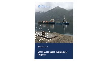
NFF offers a spotlight on the thinking and approach then, in its recent report (Publication No32) – ‘Small Sustainable Hydropower Projects’, issued in 2024. The briefing itself draws upon part of the Proceedings from the Norwegian Rockblasting Conference (Fjellsprengningsdagen), in November 2016. The Proceedings from the time are in Norwegian, the more recent small hydro report from NFF is in English.
The Vamma 12 small hydropower plant is located on the Glomma River, about 18km below Lake Øyeren. The project was both the 12th unit in the Vamma power complex yet a stand-alone plant, designed to catch the energy of highwater overflows that had previously gone untapped. Therefore, it taps the same lake and can convey up to 500m3/s of water and has an installed power capacity of 129MW.
Located on its own, Vamma 12 offered an opportunity in the rising era of digital construction. Including its underground elements, the construction project became a prime candidate to push the industry’s use of BIM. It did so notably, and deliberately, without recourse to using 2D drawings as traditional used in workflow, for detailed drawings.
The owner of the run-of-river hydropower plant is local renewables company Hafslund. The contractor for the Vamma 12 expansion was AF Anlegg, and the contract value was NKr370 million. Construction began in late 2015 and new hydropower plant came into service in early 2019.
Consultant on the project was Norconsult, which also helped worked on the approach to using BIM and then created the BIM model. The original 2016 paper was written by Øyvind Engelstad, head of hydro civil works with Norconsult, and Inge Handagard, head of BIM with AF Anlegg.
Norconsult notes, on its website, that in 2015 “the contractor established that no detailed drawings would be prepared, only digital models.”
The models provided data for the drill and blast jumbos, and in return received both automatic- and manualcollected data: the former from data of excavation progress (scans, bore logs, Measure While Drilling (MWD), etc); and, the latter from surveys, photos, etc). These allowed for updates and adjustments to the design, the authors’ said – “design as you go” revisions – and also formed the basis of the as-built documentation.
In their write-up, the authors said: “BIM helps to change the work process and to ensure good productivity, right quality and reduce rework and conflicts between stakeholders.”
Key elements in using the various software suites, at the time, included, for example: enabling the overall BIM model system to clearly support communication and in timely ways, including with the owner; quality assurance; and, linkage of model elements (e.g., blasting and excavation, formwork, reinforcement; etc) to the bill of quantities.
The construction teams could use dedicated, fixed location BIM-kiosks on site and also tablets (IPads) they carried to access the model and data from elements. The BIM model was used directly to prepare drilling plans to blast cuts, pits and tunnels. Detailed scans helped to check drilling and blast-induced overbreak, or not-to-plan over-excavation due to geology. Data from MWD logs were turned into 3D volumes to state observed geology. Scan resolution also enabled automatic categorisation of fracture planes (based on strike and dip) and zones of geology. Progress of shotcreting was determined by multiple scans. Data were input from mapping and photos during inspections.
While “operating protocols and other data can also be linked into the model,” the authors said, they added that in future, while this process can be automated as much as possible, “one cannot avoid the fact that expert engineering geologists and staff must go in to ‘touch and feel’ the rock mass”.
This is vital, they said, “to form a picture of the challenges” and “decide on recommended excavation procedure and initial support measures to be applied.”
Further, they stated that data needs “used in analysis and as a basis for permanent support, and not just collected and left as ‘dead data’.”
Finally, they assert that BIM is only a tool “and not an end in itself.” Expanding, they add that “without adaptation of the processes, and trust between stakeholders and a focus on common goals, every system will fail.”
REFERENCES
- WTC 2024: Digital & IT theme
- Anton, P.R., Teixeira, I.J.F., Barbetta, A., Vieira, B.B. & Abreau, F. (2024) ‘BIM Modelling and reality capture in underground drill & blast caverns’.
- Barbieri, G., Panicis, E.D., Bella, G., Femina, D.D., Biagi, A. & Giani, M. (2024) ‘The Sotra Link Project (Norway): An application of the BIM methodology in tunneling design and construction’.
- Catapano, M., Poli, A., Roncoroni, R. & Reis, A. (2024) ‘INFRA-BIM interoperability for tunnel renewal’.
- Huang, Y., Zhang, Z., Jia, K., Lai, H. & Li, Y. (2024) ‘Research and application of the BIM-based fine management in shield tunnelling construction of rail transit engineering’.
- Robert, F. & Dias, N. (2024) ‘Why is it worth using BIM in tunnelling?’
- Zhaofeng, Y. (2024) Research on data management and analysis of BIM technology’.

